Walking on the Island
The ever changing beauty of Holy Isle is ideally enjoyed on foot.
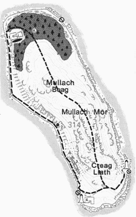
There is a nice easy walk that starts in front of the Centre for World Peace and Health (1) and follows the coastline to the south.
After walking past the Information Centre - where you can usually enjoy a free cup of tea or coffee and ask any questions to a member of the community - the walk leads past an area of newly planted trees. Then it climbs up slightly, past bracken and gorse, giving a beautiful view of Arran's mountains.
About half way down the path, the cave where St. Molaise lived (2) is indicated with a little sign pointing up some steps, followed shortly by the Holy Well. For centuries people have come to drink its cold and crystal clear water for the healing powers it is said to have, although we should point out that it does not meet current EU standards. Further south are several rock paintings (3) that depict different deities and teachers of the Kagyu Lineage of Tibetan Buddhism: White Tara, Green Tara, Milarepa, Marpa, Gampopa, Buddha Shakyamuni and Dusum Khyenpa. The path winds further down to the south, past an area where native trees have been planted, to where the Inner Light Retreat for women (4) is situated. The retreat and the adjacent gardens are closed to the public. The path continues on to Pillar Rock Lighthouse (5), where it ends. After that the path is unsafe so there is no access. The whole east side of the Island is a Nature Reserve. The distance from the Centre to the south end is roughly two miles. At a leisurely walking pace it takes about three quarters of an hour to get there.
A longer and more strenuous walk leads to the top of the mountain. This path starts between the gap in the dry stone walling next to the north end jetty, veering right between the two prayer flags and leading to the top of the field where there are some wooden stiles. After the stiles the path goes through the newly planted native woodland area (6) all the way to the top of Mullach Beag, 759ft. above sea level. After reaching this first peak, the path slopes down a bit and then up again to the windswept crest of Mullach Mor (7), 1026ft. above sea level. Caution is needed due to the loose scree found on the way up, although there are plans for improving the path in the near future. The climb down is very steep and the path leads past hidden crevasses that have been marked by blue ropes. For your own safety you are advised to keep carefully to the  paths to avoid these dangerous crevasses. The path then goes on to join up with the coastal path in the south. Walking all the way over the top and back round to the Centre takes most people between two and four hours.
Everyone is free to walk on these paths, but Rokpa Trust, the owner of the island, cannot accept responsibility for personal loss or injury.